Since they just decided to evacuate New Orleans in front of the approaching Category 4 Hurricane Gustav, here's another vignette from our trip to the Gulf Coast:
During our work trip we took one afternoon off to go to the beach in Biloxi, hoping that there might be a cool breeze off the Gulf. No such luck. The beach was deserted in the early afternoon (local Biloxians knew better) and hot as the Sahara. The sea water was literally the temperature of a warm bath and there were no waves or wind. After less than hour we were thoroughly boiled and retreated to our air-conditioned trailer. I remember thinking as I waded out into the soup kettle: warmer sea-surface temperatures lead to stronger hurricanes.
(Now I have no idea whether sea-shore temperatures actually really count for much of anything when it comes to hurricanes, but still, it was kind of scary to contemplate.)
(For more hurricane-blogging, check out Chris Mooney and Jeff Masters, and read this plea for not-forgetting from the good folks at Common Ground Relief.)
Saturday, August 30, 2008
Friday, August 29, 2008
Lower Ninth Ward
I plan to post more on our trip to Biloxi, but for now--on the 3rd anniversary of Katrina's landfall and another hurricane about to swing into the Gulf--I wanted to briefly mention our brief experience in the Lower 9th Ward of New Orleans last week.
Since we flew into New Orleans and rented a car, we decided to drive through some of the flooded neighborhoods on our way back to the airport. We came into the city from the east along Claiborne Road, and there were clear signs of devastation and rebuilding. We saw entire shopping malls boarded up, but also new and refurbished homes and stores. Maybe one in three buildings still looked badly damaged. As we drew closer to the Canal separating the Lower Ninth from the city center, we decided to take a turn off the main drag onto a side street, and...
I think Laura Jean and I might have both gasped audibly at what we saw. The entire neighborhood was just ... gone. What had once been a full neighborhood of small family homes was now returning to bayou. The grass was four feet tall. Only every twentieth home was still standing and most of those looked like they had been bombed. There were few attempts at rebuilding and even the roads were destroyed--giant potholes and standing water everywhere. It felt like driving through an Iowa cornfield, or a township. Laura Jean described it as being under the ocean.
I'm not entirely sure what I expected--perhaps more like the 'back to life' feeling from the main road--but not this field of bulldozed foundations. In a word, it was shocking.
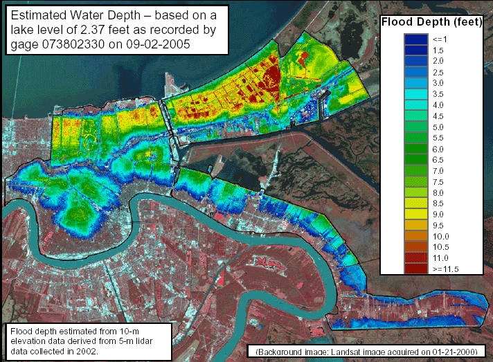
No photos to share since our camera had stopped working by that point, but this flickr set captures some of the feel of being there. Also after poking around a bit, I found this map showing the depth of the flood waters throughout the city and you can see that these houses were totally destroyed by 1-5 feet of water -- other parts of NOLA were submerged by more than 11 feet!
You can also see some of the destruction in the current google map images of the neighborhood (zoom in), although I think since these pictures were taken many of these houses have been razed to the ground.
View Larger Map
Since we flew into New Orleans and rented a car, we decided to drive through some of the flooded neighborhoods on our way back to the airport. We came into the city from the east along Claiborne Road, and there were clear signs of devastation and rebuilding. We saw entire shopping malls boarded up, but also new and refurbished homes and stores. Maybe one in three buildings still looked badly damaged. As we drew closer to the Canal separating the Lower Ninth from the city center, we decided to take a turn off the main drag onto a side street, and...
I think Laura Jean and I might have both gasped audibly at what we saw. The entire neighborhood was just ... gone. What had once been a full neighborhood of small family homes was now returning to bayou. The grass was four feet tall. Only every twentieth home was still standing and most of those looked like they had been bombed. There were few attempts at rebuilding and even the roads were destroyed--giant potholes and standing water everywhere. It felt like driving through an Iowa cornfield, or a township. Laura Jean described it as being under the ocean.
I'm not entirely sure what I expected--perhaps more like the 'back to life' feeling from the main road--but not this field of bulldozed foundations. In a word, it was shocking.
No photos to share since our camera had stopped working by that point, but this flickr set captures some of the feel of being there. Also after poking around a bit, I found this map showing the depth of the flood waters throughout the city and you can see that these houses were totally destroyed by 1-5 feet of water -- other parts of NOLA were submerged by more than 11 feet!
You can also see some of the destruction in the current google map images of the neighborhood (zoom in), although I think since these pictures were taken many of these houses have been razed to the ground.
View Larger Map
Sunday, August 24, 2008
This Does Not Bode Well...
We're back from our trip to the Gulf Coast, and I have to say, flying sure has become more annoying in the past year. The second leg of our journey was on US Airways and they:
At any rate, the flight back was uneventful and we got out just before tropical storm Fay swung through the area.
- charged us $55 to check our bags,
- tried to charge us $2 for water and $1 for coffee on the in-flight beverage service (no thanks), and, worst of all,
- we had to listen to an advertisement for a credit card offer, announced over the PA right after they completed the usual safety instructions.
At any rate, the flight back was uneventful and we got out just before tropical storm Fay swung through the area.
Thursday, August 14, 2008
withdrawal?
The internet went down at work today ... for the entire day. After the trauma subsided, I was actually fairly productive! It seems that when it comes to the internet, distraction and usefulness fight each other to a standstill. Hmm.
Anyway, we're off on more travels tomorrow - back in a week!
Anyway, we're off on more travels tomorrow - back in a week!
Tuesday, August 12, 2008
Maps: Pub Trans Edition
DC has a really great Metro system. Measured in terms of density and usefulness, I would place it on the second tier of subway systems I've experienced, behind the London Tube or the NYC subway, but better than BART, CTA and everyone else. In terms of architecture and cleanliness, it really has no equal. It's easy to gripe about, but really, the Metro is quality.
But it could always be improved! Every time I look at the system map I mentally play connect-the-dots and create new and useful subway routes. Greater Greater Washington likes this game too and resurrects a map of proposed Metro additions from the early '90s. Click the image for the full-size version; the current system map is here.

This fantasy version has some nifty features (the Dulles connection and the outbound routes to Baltimore and Annapolis would be great, and the ring line would do miracles for Beltway traffic, I'm sure) but I have to take exception to the Georgetown-Chevy Chase-Wheaton route.
Granted, a Georgetown station would be super-popular and would help the kids who want to go drinking on the weekend not have to pile into taxis to get home. But there are so, so many places in DC more in need of a Metro stop than these. Not for nothing does ggwash dub this the "rich white people's line."
Instead, we really should head north from Georgetown up to Cathedral (drop off some tourists) and then turn east back to Woodley, cross the Rock Creek into Adams-Morgan (another hit with the bar and restaurant crowd) and connect to the Green Line at Columbia Heights. From there the line could turn north up 14th or 16th streets towards Takoma and north DC.
Or, alternately, the route could continue into Northeast towards the Washington Hospital Center (currently not served by Metro!), the Rhode Island Ave station, turn south through Trinidad and Capitol Hill and connect to the Orange/Blue Lines at Potomac Ave. It could even (gasp) jump the river and add some options for the folks in Anacostia.
Anyway, those are my fantasy picks. Granted, a tradeoff does exist between expanding service for suburban commuters (which would take a lot of cars of the road) and creating a truly usable public transportation service for city and inner-suburb people that need it most (i.e. those hardest hit by rising gas prices).
Realistically, the politics of expanding Metro revolve around getting either Maryland or Virginia to pony up some cash (hence the planned Silver Line to Dulles or the Purple Line proposal) whereas increasing transit density and usefulness for DC residents falls mainly on our already overstretched tax base. Still, these types of investments are bound to payoff in the long run.
(via transit pornographer Matt Yglesias. More Metro extension proposals found here.)
Monday, August 11, 2008
Crawling!
In which Quinn crawls around, acts cute, shouts, pulls herself up on stuff...
Quinn's actually been crawling for about a month now, but this video shows off her mad skills pretty well I think. (For best results, turn down the volume - the guy talking in the background has an annoying squeaky voice, apparently.) YouTube link here.
Quinn's actually been crawling for about a month now, but this video shows off her mad skills pretty well I think. (For best results, turn down the volume - the guy talking in the background has an annoying squeaky voice, apparently.) YouTube link here.
Sunday, August 10, 2008
Katrina aftermath reading list
This coming weekend we'll be flying down to New Orleans as part of a mission trip with our church to rebuild homes (mostly in Biloxi, MS) destroyed by Katrina. Yes, it will likely be hotter than hell down there. Woo hoo.
Anyway, I've been doing a bit of reading about what's been going on in the 3 years since Katrina. Here are a few interesting articles:
Anyway, I've been doing a bit of reading about what's been going on in the 3 years since Katrina. Here are a few interesting articles:
Sunday, August 03, 2008

Subscribe to:
Posts (Atom)